- Charvil was formed as a separate parish in 1970 following the efforts of a local Residents Association. Previously Charvil had come within the ecclesiastical boundary of Sonning, was within the boundary of the civil parish of Woodley and Sandford and had Twyford as a postal address.
- The Parish of Charvil is a northern parish of Wokingham, bordered to the north by the River Thames, to the east by the parishes of Wargrave and Twyford to the south by Hurst and to the west by Sonning and Woodley.
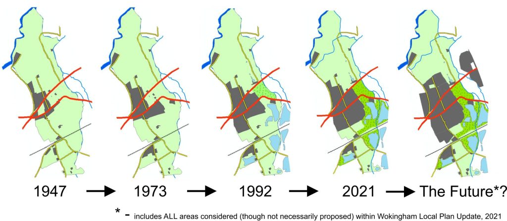
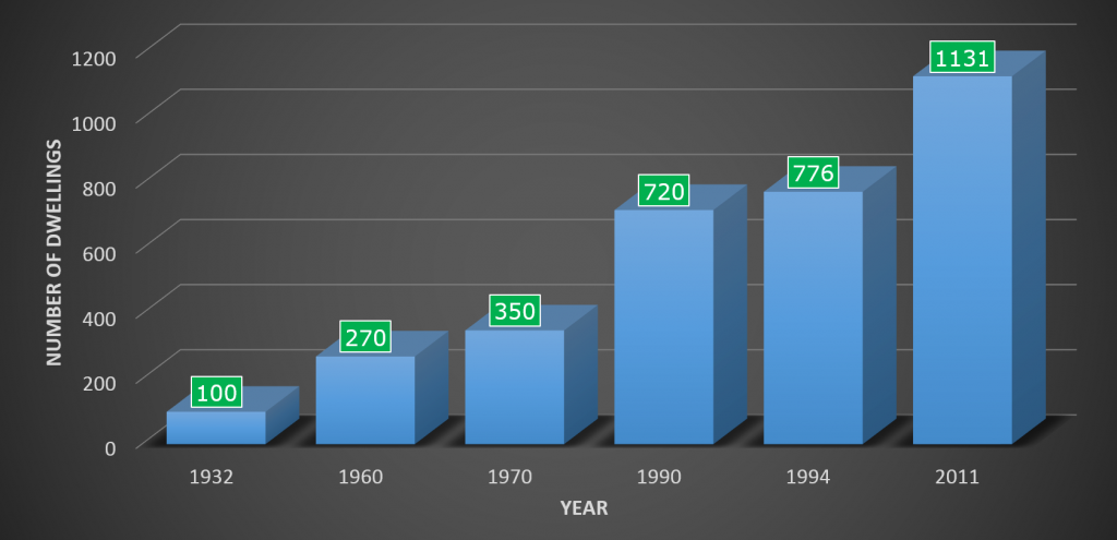
- Originally a small hamlet dominated by a number of farms and small numbers of housing, in the early part of the 20th century there were believed to be about 20 houses within its boundary, intermittent phases of significant housing development in the village and the building of the A4 road have seen the number of dwellings increase significantly. Charvil grew rapidly from the 70s onwards with three major estates built in the last three decades of the twentieth century and the population has approximately quadrupled since the 1960’s to reach 3042 at the 2011 census.
- Since the late 1990’s there have been no major developments within the village but significant infill and back-lot development has continued, four further sites are currently (April 2021) being consulted on as part of the Wokingham Local Plan Update and the two largest if accepted would add a minimum of 150 houses to the parish (see table 1).
- Services and other facilities are generally regarded as having not kept pace with population growth or have taken very long to secure (e.g. A4 roundabout and pedestrian crossing; a primary school was first proposed in 1973)
- Historically when new developments were approved significant concessions have been extracted, particularly in designing public access and wildlife areas such as Charvil Meadows and Charvil Country Park
- The ongoing Wokingham Borough Council Local Plan Update is potentially proposing further growth on the small amount of land remaining, see pie chart in Charvil Today
- As a resident what is your view? Complete the Survey
Charvil: No. of Dwelling/Yr*
| Site Reference | Address | Parish | Ward | Size (Hectares) | Land use proposed by the promoter |
|---|---|---|---|---|---|
| 5CV001 | Land East & West of Park View Drive North Charvil | Charvil | Charvil | 12.4 | Housing (C3 Planning Use Class). |
| 5CV002 | Land West of Park Lane | Charvil | Charvil | 10.7 | Housing (C3 Planning Use Class). |
| 5CV004 | 3 Norris Green | Charvil | Charvil | 0.28 | Housing (C3 Planning Use Class). |
| 5CV005 | Land to rear of Oaktree Cottage Charvil | Charvil | Charvil | 1.5 | Housing (C3 Planning Use Class). |